Resource

Mess mapping to prioritise climate risks

Stage 4

Communities most at risk prioritising their risks and considering impact assessments of their context is vital. Communities at risk engaging in a strengthened understanding of the impacts of climate change will support the process of them prioritising critical or complex/multiple risks in order for them to take decisions that will improve development, adaptation or contingency actions and build resilience.

Key ways to do this include:

  • Consolidating information
  • Consulting with experts
  • Setting up collaborative assessment processes
  • Participatory analysis of general situations
  • Resilient infrastructure/ecosystem analysis

Specifically for localising climate projections, Mess Mapping is recommended. It is also recommended that stakeholders identified (for example the National Meteorological Services and/or national climate research institution) can provide a summary of key climate trends in the national context, and a discussion can be held with them on which trends are already impacting on the community context.

Introduction

Mess mapping is one approach for addressing complex challenges that persistently negatively impact the community and seem to have no perfect solution for addressing them. However, just because there is not one solution, it does not mean that action cannot be taken to reduce the problem.

Understanding complex problems requires a holistic approach and systems perspective, which takes into account the knowledge and lived experiences of multiple stakeholders and disciplines. Mess mapping allows for multiple perspectives to come together in a collaborative process that seems messy but is actually a structured way of making sense of complexity. Mess mapping provides a means for identifying and connecting drivers and processes so that they are made explicit and transparent.

Step 1

Participants agree on a significant challenge or issue within their local context (for example water insecurity, unemployment or health crises, etc.) The issue of focus might need to be negotiated/prioritised amongst participants. This could occur through soliciting ideas from the group and then collaboratively prioritising each of the issues.

For example, one could ask participants to spend a few moments thinking about developmental issues that worry them most and to write these issues down on a post-it note. These post-it notes could then be arranged into themes and these themes presented back to the group for validation.

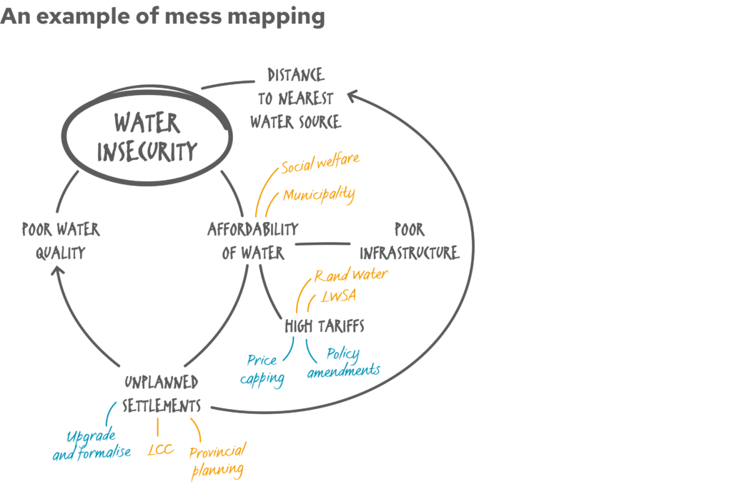
Once the set of themes are finalised, a voting process can help to prioritise the most prominent issue across the group. This issue is written in the centre of a large flip chart paper. It will act as the starting point from which participants will consider the social, economic, environmental, climate or political drivers of this issue in the area.

Step 2

In one colour, start mapping secondary issues that link to the main issue, or make it worse. For example, for water insecurity, linked issues might be affordability of water, distance to the nearest water source, poor water quality etc. Allow everyone to map their ideas on to the central issue until the ideas are exhausted.

Step 3

Expand mapped issues to the second or third degree because not all issues link directly to the central issue. For example, affordability of water is linked directly to water security. Linked to affordability of water is high water tariffs, bad infrastructure, unplanned settlements etc. Again, allow everyone to map their ideas until the ideas are exhausted.


Step 4

In a new colour, add the actors who have a role to play in each of the issues. There may be more than one actor linked to each issue and/or one actor may be linked to several issues. Where the latter is the case, the mess mapping process allows for these “central” actors to emerge.

Step 5

In another new colour, the final step allows participants to add potential solutions to emerging problems next to each area and start to draw feedback loops (positive or negative) between solutions.

The result

Once the mapping process is finalised (it will never be fully finished because of the nature of complex problems), the map should indicate prominent issues, drivers of these issues, responsible actors in the landscape and potentially how the issues, solutions and actors link together.

The mess map can provide a basis for deciding on pathways forward and solutions that cut across multiple issues in the landscape. Once you have completed your mess mapping, the next step is to reflect on how climate impacts on the risks you have identified.

Refer back to this ‘messy map’ throughout the process of next steps that consider various future projections.

Risk-Informed Development Guide

Stage four of the Risk-Informed Development Guide highlights the prioritising risk or creating impact assessments through consolidating information gathered and setting up a collaborative analysis process with the community and identified stakeholders, and completing a process of analysis to begin to prioritise issues and make decisions on what challenges to focus on – therefore what climate projection data, forecasting or climate action needs to be taken.

Stage 3

Project partners

Our Risk-Informed Development Guide was produced as part of our Local Leadership for Global Impact project. The project and all related content was funded by the German Federal Ministry for Economic Cooperation and Development (BMZ). All content is the sole responsibility of GNDR and does not necessarily reflect the views of the BMZ.

Visit their website

Our Local Leadership for Global Impact project is implemented in partnership with Diakonie Katastrophenhilfe.

Visit their website
Back to top